


Cocke County, Tennessee | |
|---|---|
 Cocke County Courthouse in Newport | |
 Seal | |
 Location within the U.S. state of Tennessee | |
| Coordinates: 35°56′N 83°07′W / 35.93°N 83.12°W / 35.93; -83.12 | |
| Country |  United States United States |
| State |  Tennessee Tennessee |
| Founded | October 9, 1797 |
| Named after | William Cocke[1] |
| Seat | Newport |
| Largest city | Newport |
| Area | |
• Total | 443 sq mi (1,150 km2) |
| • Land | 435 sq mi (1,130 km2) |
| • Water | 8.6 sq mi (22 km2) 1.9% |
| Population (2020) | |
• Total | 35,999 |
• Estimate (2025) | 37,889  |
| • Density | 82/sq mi (32/km2) |
| Time zone | UTC−5 (Eastern) |
| • Summer (DST) | UTC−4 (EDT) |
| Congressional district | 1st |
| Website | www |
Cocke County is a county on the eastern border of the U.S. state of Tennessee. As of the 2020 census, the population was 35,999.[2] Its county seat is Newport.[3] Cocke County comprises the Newport, TN Micropolitan Statistical Area, which is part of the Knoxville–Morristown–Sevierville, Tennessee Combined Statistical Area.[4]
History
[edit]Before the arrival of European settlers, the area that is now Cocke County probably was inhabited by the Cherokee. They were the most recent of a series of indigenous cultures who had occupied this country for thousands of years.
The first recorded European settlement in the county was in 1783 when land near the fork of the French Broad and the Pigeon Rivers was cleared and cultivated. The earliest European settlers were primarily Scots-Irish, Dutch, and Germans who came to the area over the mountains from the Carolinas or through Virginia from Pennsylvania and other northern states.
The county was established by an Act of the Tennessee General Assembly on October 9, 1797, from a part of Greene County, Tennessee. It was named after William Cocke,[5] one of the state's first Senators. Located within the Appalachian and Great Smoky Mountains, it had difficult conditions for early settlers.
Like many East Tennessee counties, settled by yeomen farmers, Cocke County was largely pro-Union on the eve of the Civil War. In Tennessee's Ordinance of Secession referendum on June 8, 1861, the county's residents voted 1,185 to 518 against secession.[6]
Geography
[edit]
According to the U.S. Census Bureau, the county has a total area of 443 square miles (1,150 km2), of which 435 square miles (1,130 km2) are land and 8.6 square miles (22 km2) (1.9%) are covered by water.[7] The southern part of the county is located within the Great Smoky Mountains, and the lands are protected by the Great Smoky Mountains National Park. The northern part of the county is situated within the Ridge-and-Valley Appalachians.[8] The county's highest point is Old Black, which rises to 6,370 feet (1,940 m) in the Smokies along the county's border with North Carolina.[9] English Mountain, a large ridge that peaks at 3,629 feet (1,106 m), dominates the western part of the county.
Cocke County is drained by the French Broad River, which traverses the northern part of the county and forms much of its boundary with Jefferson County. A portion of this river is part of Douglas Lake, an artificial reservoir created by Douglas Dam further downstream. The Pigeon River flows northward across the county and empties into the French Broad north of Newport at Irish Bottoms.
- Hamblen County (north)
- Greene County (northeast)
- Madison County, North Carolina (southeast)
- Haywood County, North Carolina (south)
- Sevier County (southwest)
- Jefferson County (northwest)
National protected areas
[edit]- Appalachian Trail (part)
- Cherokee National Forest (part)
- Foothills Parkway (part)
- Great Smoky Mountains National Park (part)
State protected areas
[edit]- Rankin Wildlife Management Area (part)
- Martha Sundquist State Forest
Major highways
[edit]


Demographics
[edit]| Census | Pop. | Note | %± |
|---|---|---|---|
| 1810 | 5,154 | — | |
| 1820 | 4,892 | −5.1% | |
| 1830 | 6,017 | 23.0% | |
| 1840 | 6,992 | 16.2% | |
| 1850 | 8,300 | 18.7% | |
| 1860 | 10,408 | 25.4% | |
| 1870 | 12,458 | 19.7% | |
| 1880 | 14,808 | 18.9% | |
| 1890 | 16,523 | 11.6% | |
| 1900 | 19,153 | 15.9% | |
| 1910 | 19,399 | 1.3% | |
| 1920 | 20,782 | 7.1% | |
| 1930 | 21,775 | 4.8% | |
| 1940 | 24,083 | 10.6% | |
| 1950 | 22,991 | −4.5% | |
| 1960 | 23,390 | 1.7% | |
| 1970 | 25,283 | 8.1% | |
| 1980 | 28,792 | 13.9% | |
| 1990 | 29,141 | 1.2% | |
| 2000 | 33,565 | 15.2% | |
| 2010 | 35,662 | 6.2% | |
| 2020 | 35,999 | 0.9% | |
| 2025 (est.) | 37,889 | [10] | 5.3% |
| U.S. Decennial Census[11] 1790-1960[12] 1900-1990[13] 1990-2000[14] 2010-2014[15] | |||
Racial and ethnic composition
[edit]| Race / ethnicity (NH = Non-Hispanic) | Pop 1980[16] | Pop 1990[17] | Pop 2000[18] | Pop 2010[19] | Pop 2020[20] | % 1980 | % 1990 | % 2000 | % 2010 | % 2020 |
|---|---|---|---|---|---|---|---|---|---|---|
| White alone (NH) | 27,828 | 28,278 | 32,056 | 33,598 | 32,733 | 96.65% | 97.04% | 95.50% | 94.21% | 90.93% |
| Black or African American alone (NH) | 667 | 612 | 668 | 659 | 582 | 2.32% | 2.10% | 1.99% | 1.85% | 1.62% |
| Native American or Alaska Native alone (NH) | 26 | 77 | 110 | 113 | 126 | 0.09% | 0.26% | 0.33% | 0.32% | 0.35% |
| Asian alone (NH) | 15 | 28 | 52 | 105 | 150 | 0.05% | 0.10% | 0.15% | 0.29% | 0.42% |
| Native Hawaiian or Pacific Islander alone (NH) | x [21] | x [22] | 5 | 19 | 9 | x | x | 0.01% | 0.05% | 0.03% |
| Other race alone (NH) | 28 | 2 | 18 | 11 | 46 | 0.10% | 0.01% | 0.05% | 0.03% | 0.13% |
| Mixed race or Multiracial (NH) | x [23] | x [24] | 302 | 529 | 1,399 | x | x | 0.90% | 1.48% | 3.89% |
| Hispanic or Latino (any race) | 228 | 144 | 354 | 628 | 954 | 0.79% | 0.49% | 1.05% | 1.76% | 2.65% |
| Total | 28,792 | 29,141 | 33,565 | 35,662 | 35,999 | 100.00% | 100.00% | 100.00% | 100.00% | 100.00% |
2020 census
[edit]As of the 2020 census, there were 35,999 people, 15,246 households, and 9,196 families residing in the county.[25] The median age was 46.6 years, 19.6% of residents were under the age of 18, and 22.1% of residents were 65 years of age or older. For every 100 females there were 96.5 males, and for every 100 females age 18 and over there were 94.0 males age 18 and over.[25]
The racial makeup of the county was 91.7% White, 1.6% Black or African American, 0.5% American Indian and Alaska Native, 0.5% Asian, <0.1% Native Hawaiian and Pacific Islander, 0.8% from some other race, and 4.9% from two or more races. Hispanic or Latino residents of any race comprised 2.7% of the population.[26]
32.1% of residents lived in urban areas, while 67.9% lived in rural areas.[27]
There were 15,246 households in the county, of which 26.0% had children under the age of 18 living in them. Of all households, 44.2% were married-couple households, 20.3% were households with a male householder and no spouse or partner present, and 27.7% were households with a female householder and no spouse or partner present. About 29.8% of all households were made up of individuals, and 13.7% had someone living alone who was 65 years of age or older.[25]
There were 17,808 housing units, of which 14.4% were vacant. Among occupied housing units, 71.0% were owner-occupied and 29.0% were renter-occupied. The homeowner vacancy rate was 1.7% and the rental vacancy rate was 6.3%.[25]
2000 census
[edit]As of the census[28] of 2000, 33,565 people, 13,762 households, and 9,715 families were residing in the county. The population density was 77 people per square mile (30 people/km2). The 15,844 housing units averaged 36/mi2 (14/km2). The racial makeup of the county was 96.16% White, 1.99% African American, 0.40% Native American, 0.15% Asian, 0.33% from other races, and 0.96% from two or more races. About 1.05% of the population was Hispanic or Latino of any race.
Of the 13,762 households, 29.50% had children under the age of 18 living with them, 53.10% were married couples living together, 13.00% had a female householder with no husband present, and 29.40% were not families. About 25.70% of all households were made up of individuals, and 10.10% had someone living alone who was 65 years of age or older. The average household size was 2.41 and the average family size was 2.87.
In the county, the population was distributed as 22.80% under the age of 18, 8.30% from 18 to 24, 28.80% from 25 to 44, 26.40% from 45 to 64, and 13.60% who were 65 years of age or older. The median age was 39 years. For every 100 females, there were 94.60 males. For every 100 females age 18 and over, there were 92.80 males.
The median income for a household in the county was $25,553, and for a family was $30,418. Males had a median income of $26,062 versus $18,826 for females. The per capita income for the county was $13,881. About 18.70% of families and 22.50% of the population were below the poverty line, including 31.80% of those under age 18 and 18.70% of those age 65 or over.
Communities
[edit]
City
[edit]- Newport, county seat
Town
[edit]Census-designated Place
[edit]Unincorporated communities
[edit]Notable residents
[edit]- Ben W. Hooper, governor of Tennessee from 1911 to 1915
- J. E. Rankin, banker and mayor of Asheville, North Carolina
- Popcorn Sutton, moonshiner[29]
- , actor
See also
[edit]References
[edit]- ↑ E.R. Walker III, "Cocke County," Tennessee Encyclopedia of History and Culture. Retrieved: June 24, 2013.
- ↑ "Census - Geography Profile: Cocke County, Tennessee". United States Census Bureau. Retrieved December 31, 2022.
- ↑ "Find a County". National Association of Counties. Archived from the original on May 31, 2011. Retrieved June 7, 2011.
- ↑ Office of Management and Budget, Update of Statistical Area Definitions and Guidance on Their Uses Archived April 24, 2009, at the Wayback Machine, December 5, 2005
- ↑ Gannett, Henry (1905). The Origin of Certain Place Names in the United States. Govt. Print. Off. pp. 86.
- ↑ Oliver Perry Temple, East Tennessee and the Civil War, (R. Clarke Company, 1899), p. 199.
- ↑ "2010 Census Gazetteer Files". United States Census Bureau. August 22, 2012. Retrieved April 2, 2015.
- ↑ Tennessee Department of Environment and Conservation, et al., "Ambient Air Monitoring Plan," Environmental Protection Agency website, July 1, 2010, p. 6. Accessed: March 18, 2015.
- ↑ Tennessee County Highpoints, Tennessee Landforms. Retrieved: June 24, 2013.
- ↑ "County Population Totals and Components of Change: 2020-2025". United States Census Bureau. Retrieved April 11, 2026.
- ↑ "U.S. Decennial Census". United States Census Bureau. Retrieved April 2, 2015.
- ↑ "Historical Census Browser". University of Virginia Library. Archived from the original on August 11, 2012. Retrieved April 2, 2015.
- ↑ Forstall, Richard L., ed. (March 27, 1995). "Population of Counties by Decennial Census: 1900 to 1990". United States Census Bureau. Retrieved April 2, 2015.
- ↑ "Census 2000 PHC-T-4. Ranking Tables for Counties: 1990 and 2000" (PDF). United States Census Bureau. April 2, 2001. Archived (PDF) from the original on October 9, 2022. Retrieved April 2, 2015.
- ↑ "State & County QuickFacts". United States Census Bureau. Archived from the original on June 7, 2011. Retrieved November 29, 2013.
- ↑ "1980 Census of Population - General Social and Economic Characteristics - Tennessee - Table 15 - Persons by Race: 1980 AND Table 16 - Total Persons and Spanish Origin Persons by Type of Spanish Origin and Race: 1980" (PDF). United States Census Bureau. p. 13-22. Archived from the original (PDF) on October 7, 2022 – via Wayback Machine.
- ↑ "1990 Census of Population - General Population Characteristics - Tennessee: Table 3,4,5,6 - Race and Hispanic Origin: 1990" (PDF). United States Census Bureau. p. 11-47. Archived from the original (PDF) on April 25, 2026 – via Wayback Machine.
- ↑ "P004: Hispanic or Latino, and Not Hispanic or Latino by Race – 2000: DEC Summary File 1 – Cocke County, Tennessee". United States Census Bureau.
- ↑ "P2: Hispanic or Latino, and Not Hispanic or Latino by Race – 2010: DEC Redistricting Data (PL 94-171) – Cocke County, Tennessee". United States Census Bureau.
- ↑ "P2: Hispanic or Latino, and Not Hispanic or Latino by Race – 2020: DEC Redistricting Data (PL 94-171) – Cocke County, Tennessee". United States Census Bureau.
- ↑ included in the Asian category in the 1980 Census
- ↑ included in the Asian category in the 1990 Census
- ↑ not an option in the 1980 Census
- ↑ not an option in the 1990 Census
- 1 2 3 4 "2020 Decennial Census Demographic Profile (DP1)". United States Census Bureau. 2021. Retrieved December 31, 2025.
- ↑ "2020 Decennial Census Redistricting Data (Public Law 94-171)". United States Census Bureau. 2021. Retrieved December 31, 2025.
- ↑ "2020 Decennial Census Demographic and Housing Characteristics (DHC)". United States Census Bureau. 2023. Retrieved December 31, 2025.
- ↑ "U.S. Census website". United States Census Bureau. Retrieved May 14, 2011.
- ↑ Robertson, Campbell (February 20, 2012). "Yesterday's Moonshiner, Today's Microdistiller". The New York Times. Retrieved February 21, 2012.
- ↑ Leip, David. "Dave Leip's Atlas of U.S. Presidential Elections". uselectionatlas.org. Retrieved March 10, 2018.
- Goodspeed Publishing Company, "History of Cocke County", pages 864–867 in History of Tennessee, 1887. Retrieved November 26, 2006.
- Walker, E.R. III. Cocke County, Tennessee: Pages from the Past. Charleston: The History Press (2007). ISBN 1-59629-398-5
External links
[edit]
- Official site
- Cocke County Partnership – Chamber of Commerce
- Cocke County Schools
- Cocke County, TNGenWeb – genealogy resources
| ||||||||||||||||


Municipalities and communities of Cocke County, Tennessee, United States | ||
|---|---|---|
| City | 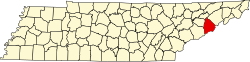 | |
| Town | ||
| CDP | ||
| Other communities | ||
| Footnotes | ‡This populated place also portions in an adjacent county or counties | |
| Principal city |     | |
|---|---|---|
| Other cities | ||
| Counties | ||
| International | |
|---|---|
| National | |
| Other | |
